Why is Dodd Road Discontiguous? A brief history of an early highway in the Twin Cities, Minnesota
I first noticed Dodd Road when I saw sections in Eagan, MN sitting near each other yet not connecting. Then, a seemingly useless 50-meter break between the otherwise-aligned Dodd Road and Dodd Boulevard on the eastern edge of Lebanon Hills Park looked so peculiar that I suspected a historical reason. An easy way to begin is to explore the road's namesake.
Captain William Bigelow Dodd was a ferry operator turned land speculator and militia captain. An energetic entrepreneur, Dodd staked roughly 500 acres on both banks of the Minnesota River at his road-head, laid out the village of Rock Bend (renamed St. Peter in 1854), and even ran "Dodd's Ferry" to carry traffic across the river. He later fell defending New Ulm in the Dakota War of 1862 (for more on that conflict and its broader impact, see my post on Walden and Bdote) and is buried behind St. Peter's Episcopal Church beneath a stone simply reading 'Builder of the Dodd Road.'
Dodd Road began in 1853 as a private subscription road cut by Captain Dodd and eleven men to link Mendota (Bdote) to Rock Bend. This model of road-building meant the colonists pooled money up front and then recouped costs via tolls or land-value gains. The subscription model let Dodd move faster than federal road acts could. Backers in St. Paul signed up to finance clearing trees, grubbing stumps, and building primitive bridges so the road would be usable by wagons. Building it as an all-season path was crucial because steamboats on the Minnesota River ran only when water levels and lack of ice allowed.
In April 1853, Dodd's crew set out from Mendota with two wagons and basic tools. For 109 days they hacked nearly 70 miles of trail through dense forest, following ridges to skirt marshy ground, bridging small streams, and marking trees. By July they reached Lake Emily just outside Rock Bend, having transformed a hunters' path into a wagon-passable highway.
Meanwhile, the U.S. Army's Topographical Engineers had funds to survey a 260-mile military road from Mendota toward the Big Sioux River. In September 1853, Captain Jesse L. Reno's party mapped across Minnesota and "stumbled" onto Dodd's freshly cut trail near Traverse des Sioux. Reno praised its quality and recommended reimbursing Dodd $3,270 (about $136,000 in 2025). The territorial assembly petitioned Congress, and Dodd received payment before the year's end. Reno noted those private improvements saved his survey weeks of bushwhacking.
Almost immediately, Dodd Road spurred settlement. Lakeville and Eureka sprang up in 1853, Millersburg in 1855, Shieldsville and Cordova in 1856, Cleveland in 1857, and Rosemount and Kilkenny by 1859. But when the Minnesota Central Railroad built a St. Paul–Faribault line in 1864, it pulled traffic off the old wagon road. Only one new town, Eidswold, was founded along Dodd Road after the railroad's arrival, a sign that trains had superseded overland wagons, especially for commercial transport.
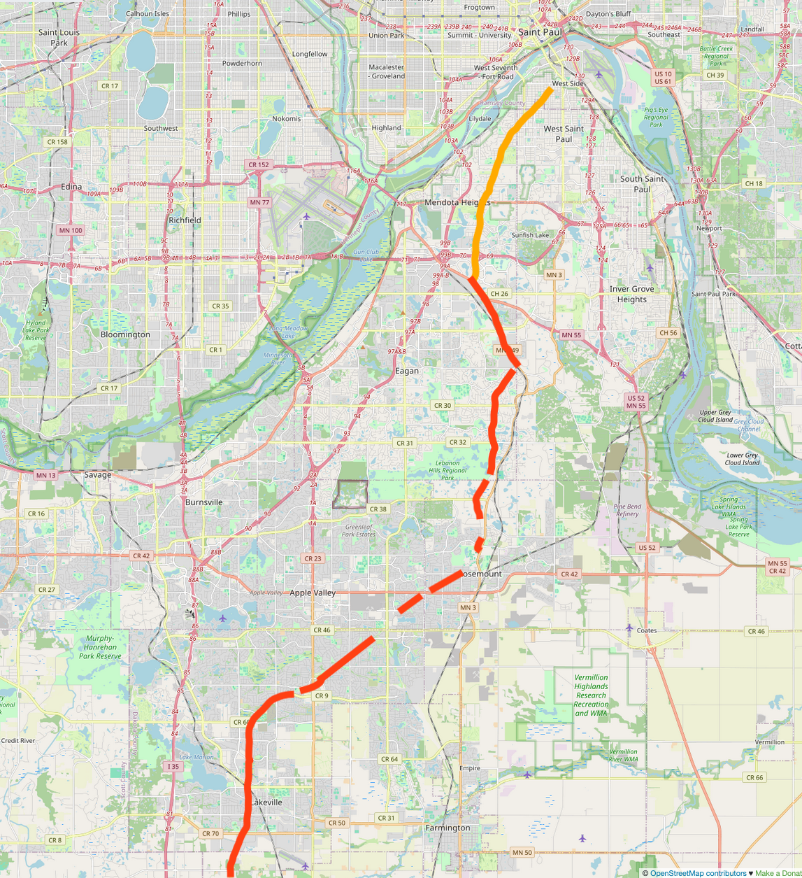
Today, Dodd's path survives in fragments in Dakota County, but the segments north of MN 55 are not on Dodd's 1853 alignment. In Saint Paul, West Saint Paul, Mendota Heights and the first few miles in Eagan, the road was built in 1921 as part of the Jefferson Highway rather than the original pioneer trace. South of MN 55, however, the road more closely follows Captain Dodd's route. Dropping south, there's a short jump west at Wescott Road, and continues paved down past Lebanon Hills, then follows the gravel-surfaced Dodd Boulevard into Rosemount, through Apple Valley and Lakeville, where the old right-of-way has never been entirely straightened, and then off out of Dakota County. The remains of this twisting path are full of gaps and jumps that trace where modern highways cut across curves, subdivisions severed right-of-way, and county priorities straightened farm-road segments. One of those gaps is the one I found along the eastern edge of Lebanon Hills: a deliberate break planted to prevent through-traffic on this now-residential road.
In 2003, three gravel portions earned National Register status: a 6.8-mile stretch in Rice County (Circle Lake Trail through Falls Trail, Garfield Avenue, Groveland Trail, Halstad Avenue) and two in Le Sueur County (County 136 west of Kilkenny and County 148 near Cleveland). None of the heavily-altered Dakota County segments made the grade. Dodd Road today feels like a time-scarred artifact you can still drive in fits and starts. Next time you hit that gravel stretch or a sudden dead end, imagine Captain Dodd's crew hacking through the Big Woods in 1853 and know every curve once linked frontier farms to a growing territory.
References
- "A History of Minnesota's Highways Part One." Streets.Mn, 9 Feb. 2018. https://streets.mn/2018/02/09/a-history-of-minnesotas-highways-part-one/.
- Brown, Curt. "Light the Candles and Pull Out the Party Hats: Dodd Road, the Mother of All Minnesotal Highway Construction Projects, Turns 150 Years Old This Summer." Star Tribune, 11 June 2003.
- "Dodd Road Discontiguous District." Wikipedia, 24 Feb. 2024. https://en.wikipedia.org/w/index.php?title=Dodd_Road_Discontiguous_District.
- "Lost Highway: Dodd Road, Dakota County." Dead Pioneer. https://deadpioneer.com/articles/dakota/doddroad/doddroad.htm.
- National Park Service. Dodd Road Discontiguous District: National Register of Historic Places Registration Form. Washington, DC: U.S. Department of the Interior, National Park Service, June 13 2003. https://npgallery.nps.gov/NRHP/GetAsset/NRHP/03000520_text.
- Wolston, Bill. "On the 150th Anniversary of the Elusive Dodd Road." Over the Years: Journal of the Dakota County Historical Society, October 2003.